


W - 2018 - 20 La Charmée

clabidault
User
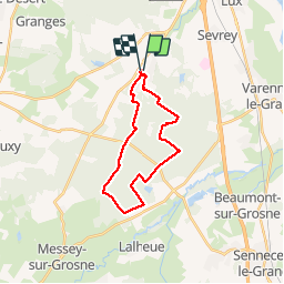

Length
21 km

Max alt
227 m

Uphill gradient
167 m
Km-Effort
23 km

Min alt
180 m

Downhill gradient
164 m
Boucle
Yes
Creation date :
2018-11-04 08:58:28.63
Updated on :
2019-01-01 15:07:32.677
4h39
Difficulty : Very easy

FREE GPS app for hiking
 SityTrail
IGN / Geographical institutes
SityTrail Plus
The world is yours!
About
Trail Walking of 21 km to be discovered at Bourgogne-Franche-Comté, Saône-et-Loire, La Charmée. This trail is proposed by clabidault.
Positioning
Country:
France
Region :
Bourgogne-Franche-Comté
Department/Province :
Saône-et-Loire
Municipality :
La Charmée
Location:
Unknown
Start:(Dec)
Start:(UTM)
637173 ; 5175942 (31T) N.
Comments